
About the Data
Local Employment Dynamics
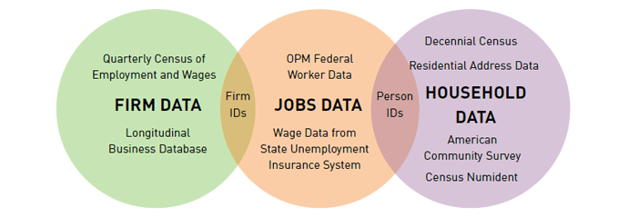
This study uses the Version 7 LEHD Origin-Destination Employment Statistics (LODES) data from the 2011 Longitudinal Employer-Household Dynamics (LEHD, LED for short) program, managed by the U.S. Census Bureau. Published annually, the 2011 data are the most current LODES dataset at the time of publication for this study. The LED data are produced through a voluntary partnership between state labor market information (LMI) agencies and the Census Bureau. LMI agencies provide wage records from their Unemployment Insurance wage record system and firm characteristics from the Quarterly Census of Employment and Wages (QCEW) to the Census Bureau, and these data are paired with Census Bureau records, including worker demographic characteristics and home addresses. This pairing enables the examination of where workers live and where they work.
Because the data are created using wage records, certain employment classes are not fully accounted for by the LED dataset. These include self-employed persons, individuals compensated as business partners, informal employment, uniformed military employment, and federal employees requiring identity protection. The LED program estimates that the dataset covers approximately 95% of all U.S. private-sector employment. Additionally, because workers and jobs are allocated to Census Blocks based on where employers process payroll, employee and job totals for large employers are occasionally aggregated to these addresses rather than physical work sites. This can produce both undercounts and overcounts. Finally, since partnerships between LMI agencies and the Census Bureau are voluntary, certain geographies are omitted due to state capacities and current data-sharing restrictions. Missing data include:
- All data for Massachusetts, Puerto Rico, and the U.S. Virgin Islands
- Arizona (2002 and 2003), Arkansas (2002), Washington, DC (2002-2009), Mississippi (2002 and 2003), and New Hampshire (2002)
Using the LED dataset for this study poses challenges in a few cities/places, most notably Boston, MA; Washington, DC; and Aurora, CO. Where Boston appears in this study, the commercial area was estimated using locally accepted definitions and American Community Survey data. Employment numbers for Boston were excluded from summary data, and estimates for population were calculated using 2010 Census data for this geographic area. Because Washington, DC LED data are only available beginning in 2010, no rates of change for jobs were calculated for DC between 2002 and 2011. Both Washington, DC and Aurora, CO include large numbers of uniformed military employment and intelligence workers, for whom data are not available, thus skewing estimates of the concentration of jobs in some cases.
The LEHD Infracture Data¹
Decennial Census
The Decennial Census is conducted every 10 years by the U.S. Census Bureau and represents a full, home-based population count of everyone who lives in the United States on April 1 in all years ending in “0.” The Decennial Census has been administered every 10 years since 1790 as required by the U.S. Constitution. For the purposes of this analysis, 2010 Census data were used at the Census Tract level to derive population totals for 2010, and 2000 Census data at the Block level were used to calculate population totals for comparable areas due to the revision of Census Tracts during the tabulation of each Decennial Census. As a result, 2000 and 2010 data for small areas such as those used in this study are not always fully comparable. Finally, while tracts must conform to Incorporated Places, they do not always conform to the boundaries of Census Designated Places, creating minor anomalies in live-work calculations and other statistics mentioned in this study.
Research Process
The data displayed in this report were produced through the following process:
- Determining the geographic universe—In order to determine the list of cities/places analyzed in this report, we examined the list of all Places in the LODES data to determine the 150 places that had the largest numbers of Primary Jobs (workers).
- Defining the employment node—From this list, we determined the existence of job nodes primarily based on visual job-density levels, with some additional input from local partners. Employment node definitions were developed at the Census Tract level in order to ensure that local areas could easily use these definitions to access additional Census data products. In some cases, the area of densest employment did not represent a traditional downtown. In these cases, where traditional downtown areas existed but were less dense, the traditional downtown was labeled the “Primary Downtown,” and other areas of dense employment were labeled “Secondary Employment Nodes.” Where no traditional downtown existed, the area of highest employment was labeled “Primary Downtown.” For example, Overland, KS’s areas of dense employment are exclusively office parks. Other areas include employment nodes that are exclusively a function of the unique geography of employment in the local economy, including Buckley Air Force Base in Aurora, CO and the port in Newport News, VA.
- Selecting Census Tracts within a half-mile and one-mile orbit from the commercial downtown—Once employment node definitions were determined, a buffer analysis from the edges of the node’s Census Tracts was performed in GIS. Data were displayed in the North America Lambert Conformal Conic projection, and tracts were included in the buffers when the centroid (mathematical center) of their polygon fell within the half-mile or one-mile distance from the edge of the commercial downtown tract(s). Half- and one-mile area definitions were developed at the Census Tract level in all cities in order to keep the methodology consistent and ensure that local areas could easily use these definitions to access additional Census data products without the use of GIS software. Census Tracts that fell within the half-mile or one-mile radii, but were located in a different state than the commercial area, were excluded. In cases where two employment nodes were in close proximity to one another, tracts for the half- and one-mile radii were assigned to commercial areas based on which commercial area’s boundary was in closest proximity to the tract’s centroid. Where tract assignments were questionable, we erred on the side of assigning the tract to the primary employment node.
- Calculating population, workforce, and live-work characteristics for the commercial downtown, half-mile, and one-mile areas—After determining boundaries, resident population statistics were calculated by these geographic definitions for 2010 Census data. Total jobs statistics were calculated using Total Jobs data for each of the tracts identified in the buffered areas. Finally, live-work statistics were calculated using Primary Jobs data by taking the number of workers who live and work in an area divided by the total number of workers living in an area. Primary Jobs differ from Total Jobs: if an individual holds more than one job, Primary Job statistics are computed for the job at which a worker earns the highest wage.
- Creating maps that represent these boundaries— Maps for the commercial and residential downtown boundaries were created to show the borders of each area for the purposes of soliciting feedback on these definitions, refining the research methodology, and ultimately producing the summary statistics displayed in this report. Representatives from 72 cities, where we identified local contacts, were asked to provide comments on their commercial downtown boundaries.
Software
Research and design for this project were conducted using:
- R, a free software programming language and statistical computing environment
- Esri ArcGIS 10.1, a geographic information systems software package
- Microsoft Excel
- Adobe CS5
- WordPress, using a modified theme by ThemeTrust
¹ LEHD Program, U.S. Census Bureau
